Interesting rock formations
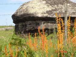
The Mushroom
This region offers many interesting rock formations and grottos, waiting to be explored.
Esta região oferece ao visitante vários atrativos geoturísticos, geomonumentos (afloramentos rochosos), sítios paleontológicos e história da mineração.
Esta região oferece ao visitante vários atrativos geoturísticos, geomonumentos (afloramentos rochosos), sítios paleontológicos e história da mineração.
Stone paths formed by ancient glaciers
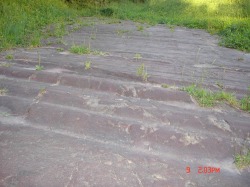
Glacier imprint
A much visited tourist stop, these markings are a great monument to the glaciers that once flowed in this area.
To date the only known proof of a glacier to have existed in all of Brazil. (See Museo Guido Borgomanero).
Also interesting to geologists and palenteologists are the many seashell fossils to be found in this 3,000 ft (1000 m) high altitude.
To date the only known proof of a glacier to have existed in all of Brazil. (See Museo Guido Borgomanero).
Also interesting to geologists and palenteologists are the many seashell fossils to be found in this 3,000 ft (1000 m) high altitude.
Witmarsum Mennonite Museum
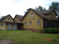
The original fazenda buildings
Mennonite history and artifacts.
Old bridge near Witmarsum #1 entrance from BR-277
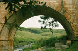
Someone traveling along the new highway BR-277 towards Palmeira would not suspect the presence of this beautiful old bridge, which is hidden behind a grove of Canadian pine trees (!!) shading a highway rest stop. In the early days of the Mennonite settlement - circa 1958 — the old road took us over this bridge when traveling from Curitiba to Palmeira.
Perhaps one day somebody will realize the historical value of this bridge and restore it to full view to the passersby.
Perhaps one day somebody will realize the historical value of this bridge and restore it to full view to the passersby.
Ponte Velha, Palmeira
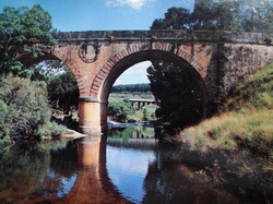
Did the Roman Aqueduct serve as model for this bridge?
The design details of this old bridge remind one of the ancient Roman Aqueduct at Garde River, France.
It is sometimes said that the arch originated with the Romans. This should be differently stated; the arch itself they did not originate, but they applied it with great skill and success to various works of utility, and made it a universal feature in civil buildings.
It is sometimes said that the arch originated with the Romans. This should be differently stated; the arch itself they did not originate, but they applied it with great skill and success to various works of utility, and made it a universal feature in civil buildings.
Vila Velha
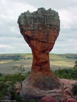
A Taça — The Wine-glass, sandstone sculpture
Vila Velha is a must see: natural sculptures in eroded arenite, just half an hour from Witmarsum.
As esculturas naturais em arenito de Vila Velha constituem um impressionante exemplo de relevo ruiniforme, derivado da associação de processos erosivos com características preexistentes da rocha. Embora protegidas por parque estadual, têm recebido cerca de 200.000 visitantes/ano, o que proporciona alguns riscos à preservação de tão rico patrimônio natural.
O Arenito Vila Velha, incluído no Grupo ltararé (Carbonífero Superior a Permiano Inferior da Bacia do Paraná), possui coloração avermelhada pela presença de cimento ferruginoso.
Photo: Mario de Sergio Melo
A área do sítio de Vila Velha reúne, além da notoriedade geológica/geomorfológica de seus arenitos, uma importância ecológica significativa para os ecossistemas da região dos Campos Gerais. Em seus limites estão preservados ou parcialmente preservados capões de mata de araucária, bem como regiões de campos limpos e depressões brejosas, ecossistemas muito degradados fora dos limites das unidades de conservação. Neles estão presentes 27 espécies vegetais endêmicas da região dos Campos Gerais (Hatschbach & Moreira Filho,1972).
Estes ecossistemas são ainda habitados por numerosa fauna pertencente à Província Faunística Guarani (Mello Leitão,1947), com muitas espécies ameaçadas de extinção, podendo-se destacar o lobo guará, Chrysocyon brachyurus.
Paraná
Paraná is a state in southern Brazil. With its strong northern European heritage, its culture is probably unlike most foreigners' image of Brazil.
REGIONS:
Paraná is commonly divided into the following regions:
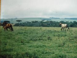
Campos Gerais: this land of fields is close to Curitiba. Curious rocky formations and canyons near Vila Velha.
Centro - this central region attracts rural tourism.
Costa Norte: the north "coast" borders the State of São Paulo. Water sports, fishing and leisure.
Costa Oeste: the west "coast" has the Iguaçu Falls and National Park, and the giant Itaipu power plant.
Curitiba - The metropolitan region contains the state's capital and its neighboring areas;
Litoral: the state's coast has several bays and mangroves, the mountains of Serra do Mar and its mata atlântica forests, as well as beaches and eco-tourism at Ilha do Mel
Vale do Iguaçu: bordering the State of Santa Catarina, water sports on lake Itaipu.
REGIONS:
Paraná is commonly divided into the following regions:
Campos Gerais: this land of fields is close to Curitiba. Curious rocky formations and canyons near Vila Velha.
Centro - this central region attracts rural tourism.
Costa Norte: the north "coast" borders the State of São Paulo. Water sports, fishing and leisure.
Costa Oeste: the west "coast" has the Iguaçu Falls and National Park, and the giant Itaipu power plant.
Curitiba - The metropolitan region contains the state's capital and its neighboring areas;
Litoral: the state's coast has several bays and mangroves, the mountains of Serra do Mar and its mata atlântica forests, as well as beaches and eco-tourism at Ilha do Mel
Vale do Iguaçu: bordering the State of Santa Catarina, water sports on lake Itaipu.
Mapa geológico do Estado do Paraná
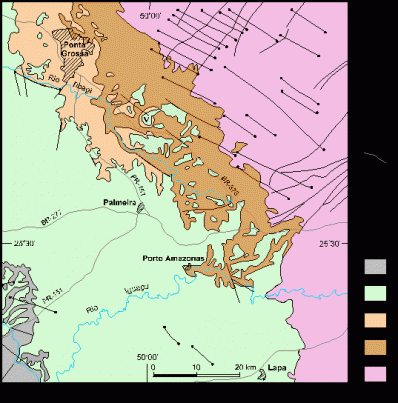
Geologic map of Paraná State between Ponta Grossa and Lapa (MINEROPAR, 1989). 1: Proterozoic basement; 2-coral area Furnas Formation (D); 3: Ponta Grossa Formation; 4: Itararé Group (C-P); 5: Rio Bonito Formation (P); diabase dykes (Mesozoic); 7: major faults; 8: Vila Velha; 9: urban areas.
Mapa geológico do Estado do Paraná entre Ponta Grossa e Lapa (MINEROPAR, 1989). 1: embasamento proterozóico; 2-area de cor coral: Formação Furnas (D);
3: Formação Ponta Grossa (D); 4: Grupo Itararé (C-P); 5: Formação Rio Bonito (P); 6: diques de diabásio (Mesozóico); 7: principais falhas; 8: Vila Velha; 9: áreas urbanas.
